HOME ABOUT SERVICES BLOG CAREERS CONTACT
As-Builts
Updated April 2026

Fiber Optic As-Built Documentation Services

Field-verified. GIS-integrated. BEAD-ready. We close out your fiber build with documentation that actually reflects what's in the ground and on the poles — not what the design said should be there.

44,000+
Miles Documented
2.6M+
Addresses Engineered
22
Active States
600+
Field Engineers

Fiber Optic As-Built Documentation: The Build Is Done. The Work Isn't.

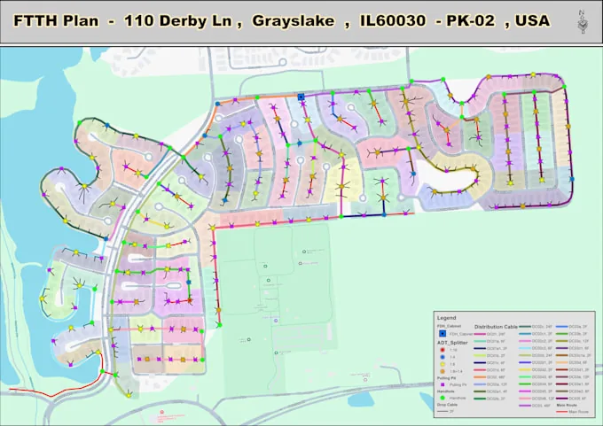
Fiber optic as-built documentation services capture the final installed condition of a network — verified cable routes, splice locations, attachment heights, conduit system layout, and equipment placements — in GIS and CAD formats suitable for network operations, future expansion, and BEAD program closeout compliance. Missing or incomplete as-built records are a primary driver of increased long-term network operating costs.

There's a version of this I've seen play out on probably a third of the projects we inherit from other firms. Construction is complete, the ISP's marketing team is already announcing service availability — and nobody can tell you exactly where the splice vault is at station 47+83, because the contractor's field notes were on paper that got rained on, and nobody updated the design database.

That's not a hypothetical. We walked that exact situation on a BEAD-funded deployment in central Georgia, 147 miles of aerial and underground, where the closeout package was basically a ZIP file of low-resolution photos and a spreadsheet that hadn't been touched since the permit phase. The first time a dig crew hit an unmarked conduit stub and put a backhoe through a live cable, the post-mortem traced straight back to missing as-built records.

Fiber optic as-built documentation services aren't glamorous. Nobody wins awards for good record-keeping. But after 15-plus years of watching networks get built, re-spliced, expanded, and repaired, I'd argue that as-built quality is one of the two or three factors that most directly determines long-term network operating costs — right up there with cable quality and splice loss.

BEAD requirement note: NTIA's BEAD program requires subgrantees to submit final network documentation — see our BEAD subgrantee engineering compliance checklist for the full requirements as part of project closeout. That includes verified as-built records, GIS data, and photographic evidence of construction. Missing or incomplete as-builts can jeopardize final payment disbursements.

We've built our as-built workflow around the assumption that the construction crew did their job — they just didn't have the documentation infrastructure to capture it properly. Our team comes in, reconciles the field data, fills the gaps, and produces a final record set you can actually use.

Fiber optic as-built documentation and field records
What We Document
  • ✓ Cable routes (aerial and underground)
  • ✓ Splice enclosure locations and records
  • ✓ Pole attachment heights and hardware
  • ✓ Conduit system layout and depth
  • ✓ FDH and closure equipment placements
  • ✓ Fiber count and assignment records
  • ✓ Deviation notes from design drawings

What Goes Into Complete Fiber Optic As-Built Documentation

A real as-built package covers more than cable routes. Here's what we capture on every project, and why each piece matters when the network needs to be repaired or expanded five years from now.

📍

Cable Route Documentation

GPS-verified centerline geometry for all aerial and underground cable segments, with measured offsets from property lines, road edges, and landmarks. If the bore went 14 feet off the planned alignment, we document the actual path — not the design path.

🔗

Splice Records & Fiber Assignments

Every closure gets documented: location coordinates, closure type and model, fiber counts in and out, and splice assignments from the splice schedule. We reconcile against the design splice plan and flag any deviations. Fiber assignments that changed in the field get updated in the record set.

🏗️

Pole Attachment Records

Actual attachment heights, hardware installed, mid-span measurements, and guy wire additions. For joint-use poles where the fiber went on after other attachments shifted, we record the final configuration — which is often different from what the make-ready design showed.

🔌

Conduit System Documentation

Conduit sizes, duct assignments, manhole and handhole locations with GPS coordinates, depth measurements at crossings, and sub-bore logs. We include the vault/hand-hole access lid locations — the ones that are invisible once the landscaping grows back.

📦

Equipment Location Records

FDH cabinets, splice closures, amplifier locations, repeater huts, node sites — every piece of active and passive equipment gets a coordinate, a photo, and an attribute record with model number and installation date. This is the foundation of your network asset inventory.

📸

Photo Documentation

Geotagged construction photos organized by station or pole number, covering key milestones: splice points before closure, trench profiles at crossings, conduit transitions, equipment installations, and any conditions that deviated from the design. We don't dump 4,000 unlabeled photos on you.

How Our Fiber As-Built Documentation Process Works

Our fiber as-built documentation process begins with a data intake and gap assessment against the construction package, followed by field verification of missing records, GIS and CAD reconciliation of all deviations, QA/QC review by a second engineer, and final delivery of stamped plan sheets, updated GIS exports, splice records, and photo logs formatted for BEAD closeout or network management system ingestion.

This is the actual workflow — not a sales chart. Different projects require different approaches depending on what the construction team captured.

The first call we have with a client about as-builts is mostly me asking what the construction team gave us. The answer shapes everything. Best case: the crew was running Fulcrum or Katapult in the field, GPS-logging every pole and splice point, and someone QC'd the data weekly. That project is straightforward — we're reconciling field data against design, resolving attribute conflicts, and outputting a clean record set.

Worst case: the contractor worked off paper markups, the PM took photos with a personal iPhone, and the field notes went back to an office that's since been closed. That project needs a partial field verification sweep before we can produce anything reliable. We've done both — and everything in between.

Either way, the output is the same: a complete, QC'd as-built package that we'll stake our name on. We don't deliver half-finished documentation and tell you to fill in the gaps.

On a 193-mile BEAD deployment outside Morgantown, WV, the construction contractor delivered GPS tracks but hadn't attributed any of the splice points. Our team spent 6 days in the field doing structure-by-structure verification to close the gaps before we could lock the GIS database. That's not unusual — it's part of the job.

One thing I'll say about process: the earlier we get involved, the better the outcome. When we're embedded with the construction team from day one — reviewing field data weekly, flagging incomplete records before the crew moves to the next section — the closeout is cleaner, faster, and cheaper. Trying to reconstruct what happened eight months after construction is harder than it sounds, even with good GPS equipment involved.

See how accurate field data collection from the start shapes the entire as-built process in our article on field survey data accuracy in fiber construction.

01

Data Intake & Gap Assessment

We receive all construction deliverables — GPS logs, field redlines, photos, contractor markups — and do an initial gap analysis against the design package. Missing data gets flagged immediately so we can plan any needed field verification.

02

Field Redline Capture

Where field notes are incomplete or paper-only, our field team deploys with GPS equipment and Fulcrum to capture missing structure locations, attachment heights, and conduit access points. We use survey-grade GPS at critical crossings and measurement points.

03

GIS & CAD Reconciliation

Field-verified data gets reconciled against the design database in ArcGIS or the client's GIS platform. Cable route geometry gets corrected. Attributes get populated. Splice records and fiber assignments get matched to the updated plant.

04

QA/QC Review

A second engineer reviews all updated records against the original design set, construction photos, and material submittals. We check for geometric inconsistencies, missing attributes, and splice assignment errors before anything goes to the client.

05

Final Deliverable Package

Stamped plan sheets, updated GIS exports, splice records, photo logs, and deviation notes — all organized to the client's standards and formatted for permit closeout, BEAD reporting, or network management system ingestion.

As-Built GIS Integration and Network Database Updates

As-built GIS integration updates the network's operational database — not just the paper drawings — with verified installed geometry, cable attributes, splice records, and equipment locations. When a field technician locates a fault at 2 AM, they need accurate GIS data, not a PDF plan set. Our as-built workflow treats the geodatabase update as the primary deliverable, with plan sheets as a byproduct of correct GIS data.

A lot of firms deliver as-builts as PDFs and call it done. That works for permit closeout. It doesn't work for network operations. When a tech goes out to locate a fault at 2 AM, they're not flipping through a binder of plan sheets — they're pulling up the network in ArcGIS or IQGeo on a tablet and trying to figure out which splice vault they need to open.

Our as-built workflow treats the GIS database update as the primary deliverable. For a full overview of fiber network as-built GIS documentation standards, see our dedicated guide, not an afterthought. The PDF plan sheets are a byproduct of the GIS. If the geometry and attributes are right in the database, the drawings generate cleanly. The reverse isn't true.

We work in ArcGIS (including ArcGIS Utility Network), QGIS, IQGeo, and GE Smallworld — whatever the client is running. We've also migrated legacy as-built records from old AutoCAD files into modern GIS platforms when clients are upgrading their network management infrastructure. That's not a small project, but it pays off quickly when you're doing it as part of a major construction closeout rather than trying to do it in isolation later.

On BEAD-funded projects specifically, we align the GIS deliverables with state program office requirements — and those vary significantly by state. Some states want specific attribute schemas. Some have their own GIS templates. We've worked through the requirements in 11 BEAD-active states as of early 2026 and have built-in familiarity with each state program's closeout process. For a deep dive into the engineering requirements that BEAD programs impose, see our coverage of BEAD funding engineering requirements for 2026.

Platforms We Work In

  • Esri ArcGIS / ArcGIS Pro — including Utility Network model and feature service publishing
  • QGIS — for clients on open-source GIS stacks or state programs requiring QGIS-compatible formats
  • IQGeo — network documentation and operations workflow integration
  • GE Smallworld — legacy network model reconciliation and data entry
  • AutoCAD / MicroStation — plan sheet production and CAD-based as-built packages

GIS Deliverable Formats

  • File geodatabase (ESRI .gdb) or enterprise geodatabase connections
  • Shapefile exports (.shp) for interoperability
  • GeoJSON for web platform ingestion
  • KMZ/KML for field visualization
  • Georeferenced DXF/DWG for CAD platforms
  • Excel/CSV attribute tables for asset management systems

The broader value of getting your GIS right is covered well in our blog post on GIS fiber network planning and cost reduction — worth a read if your organization is debating how much to invest in the data side of infrastructure operations.

BEAD-Compliant As-Built Documentation: What the Deliverable Package Includes

BEAD-compliant as-built documentation requirements include verified network GIS data, stamped as-built plan sheets, photographic construction evidence, splice records, and deviation notes from design — all organized to NTIA program office standards. Incomplete or non-conforming as-built submissions can jeopardize final disbursement payments. State BEAD programs have varying attribute schema and format requirements, which we've mapped across 11 active states.

Every client has different standards for what an as-built package needs to contain, how it needs to be organized, and what format the drawings need to be in. We've worked to the standards of major ISPs, electric co-ops, municipal broadband authorities, and BEAD subgrantees — and the requirements are rarely the same twice.

What we don't do is show up with a generic template and make you adapt to our workflow. We adapt to yours. That means reviewing any client CAD standards, GIS schemas, or documentation requirements before we start — not after we've already produced 300 pages of plan sheets that need to be reformatted.

Standard Package Components

Across most projects, the final as-built delivery includes:

  • Plan sheet set (DWG and PDF) — updated route drawings at the same scale as the construction package, with all field deviations reflected and the standard revision block updated
  • Splice record documentation — a closure-by-closure record with coordinates, fiber count, tray assignments, and splice loss readings if the contractor ran OTDR testing
  • Pole attachment records — attachment heights, hardware as-installed, and make-ready completion verification
  • Underground as-built sheets — bore and trench profiles at road crossings, manhole/handhole schedule with coordinates, conduit duct assignments
  • Equipment installation records — FDH and closure inventory with GPS coordinates, model numbers, and installation photos
  • Deviation log — a summarized record of every field change from the original design, with reason codes (utility conflict, terrain, permit condition, owner request)
  • Photo documentation set — organized by structure or station number, geotagged, and searchable
  • GIS database export — updated to reflect all of the above, in the client's native platform format

For BEAD-funded projects, we also prepare the documentation index and summary reports required for state program office closeout submissions. We've seen projects get delayed on final disbursement because the as-built package didn't match what the state program expected — usually a formatting issue or a missing attribute field. We know what each state wants and build that into the deliverable structure from the start.

On timing: We can mobilize for post-construction documentation within 5–7 business days of project completion notice. For concurrent documentation (embedded during construction), we typically need 2 weeks lead time to staff and sync with the construction team's schedule.

If you're working with a CAD/GIS design team that built the original design package, the handoff to as-builts is cleanest when we can work directly from the same base files. If the design was done by another firm, we still need that design package — it's the baseline everything gets measured against. For projects still in the design or survey phase, our field survey team can establish the data-capture protocols during construction that make as-built closeout significantly faster.

As-Built Documentation FAQ

The questions we hear most often — answered directly.

As-built documents are the final, field-verified record of how a fiber network was actually constructed — as opposed to how it was originally designed. They capture the true cable routes, splice locations, conduit depths, pole attachment heights, equipment placements, and any deviations from the design drawings that happened during construction. Every serious fiber operator needs these to manage the network going forward.
Without accurate as-builts, every future splicing job, repair crew, or network expansion starts from incomplete information. Technicians dig in the wrong location, hit unmarked conduit, or can't locate the right splice point — all of which cost real money. BEAD program reporting also requires verifiable as-built records as part of project closeout. The documentation isn't optional; it's how you protect your investment.
Design drawings show the planned network — the intended routes, equipment placements, and fiber counts before anyone picks up a shovel or climbs a pole. As-built drawings reflect what was actually built. Routes often shift during construction due to terrain, existing utilities, permitting constraints, or contractor field decisions. As-builts capture those deviations and become the permanent network record.
Turnaround depends heavily on project scale and how well the construction crew captured field data during the build. A well-documented 50-mile aerial build with clean redlines can be processed in 3–4 weeks. A 200-mile underground route where the contractor used paper markups and minimal GPS logs can take 10–14 weeks, especially when field verification trips are required. The single biggest factor is data quality from the crew.
Yes — GIS updates are a core part of our as-built workflow. We reconcile the field-verified data against the original design files and push the corrected geometry, attributes, and splice data into the client's GIS platform. We work in ArcGIS, QGIS, IQGeo, and GE Smallworld depending on what the client runs. The goal is one authoritative network record, not a pile of PDFs sitting in a folder.
We deliver in whatever format the client's workflow requires. That typically means AutoCAD DWG or DXF for plan sheets, geodatabase or shapefile exports for GIS, PDF stamped drawings for permit closeout, and Excel or CSV splice records for database ingestion. For BEAD-funded projects, we align deliverables with the state program office's documentation standards.

Close Out Your Build Right

Whether you're wrapping up a construction project, dealing with a documentation backlog, or need concurrent as-built support embedded with an active crew, we've worked through all of those scenarios. Our team handles as-built documentation across 22 states, from a 12-mile rural FTTH build to a multi-state middle-mile deployment. Reach out and tell us what you're working with — we'll be direct about what it takes and what the turnaround looks like.

Talk to Our Team

Or email us directly: info@draftech.com