- What Strand Mapping Is — and What It's Not
- Equipment: What a Proper Field Survey Crew Carries
- Step 1: Pre-Field Preparation
- Step 2: Pole-by-Pole Data Collection
- Step 3: What Gets Documented at Problem Poles
- Step 4: End-of-Day QC and Data Submission
- Step 5: How Strand Map Data Feeds Into Engineering
- Common Mistakes That Compromise the Whole Survey
Ask any OSP engineer where most design errors come from, and the honest ones will tell you: the field data. Not the engineering software. Not the design methodology. The field data. Strand mapping and aerial plant assessment are the foundation everything else is built on — pole loading analysis, make-ready calculations, fiber route design, construction cost modeling. When the field data is wrong, all of it is wrong. The strand map is where the project either starts on solid ground or accumulates the hidden errors that surface as change orders six months later.
We've done this work across thousands of poles in 22 states — mountains in western North Carolina, coastal terrain in Louisiana, dense urban corridors in Atlanta. The process has a lot in common from project to project, but the places it breaks down tend to be specific and predictable. This is a walkthrough of how strand mapping actually happens in the field, what good data collection looks like, and where the common failure points are.
What Aerial Plant Strand Mapping Is — and What It's Not
Strand mapping is a systematic field inventory of existing aerial utility plant, producing a GPS-attributed dataset documenting every pole, attachment, span, and infrastructure element in a defined corridor. The output feeds directly into pole loading analysis, make-ready engineering, and fiber attachment applications. It's distinct from a desktop review — strand mapping requires boots on the ground at every pole to capture measured attachment heights, observed conditions, and mid-span geometry that aerial imagery cannot provide.
Strand mapping is a systematic field inventory of an existing aerial utility plant. The output is a dataset — or in older workflows, a paper-based pole card system — that documents every relevant attribute of every pole in a defined geographic area. That includes the pole itself, every attachment on the pole, every span of cable or messenger wire between poles, and any associated infrastructure like anchors, guys, and equipment enclosures.
It is not a drive-by. It's not a GIS review from the office. It's not pulling records from a utility company and assuming they're current. Those approaches exist, and they're used, and they consistently produce data quality problems that show up when construction starts. The only way to know what's on a pole is to stand under it and look at it.
The aerial plant assessment component adds a structural condition evaluation layer to the data collection. Beyond what's on the pole, you're assessing the condition of what's there: pole class and species visible from ground level, visible rot indicators, tilt angle, lean direction, attachment heights measured or estimated, strand sag condition, and equipment enclosures for approximate age and clearance compliance. This data is what feeds into pole loading analysis — covered in detail in our pole loading analysis with O-Calc Pro guide — so the quality of the structural assessment directly affects the quality of the loading calculations.
Equipment: What a Proper Field Survey Crew Carries
A two-person strand mapping crew needs specific tools to collect data that's actually usable. This isn't complicated equipment, but the crew that shows up with just a clipboard and a phone camera is going to produce data that requires significant QA revision before it can support engineering work.
Measurement and positioning tools
- Laser rangefinder / clinometer combo — for measuring attachment heights without climbing. Leica Disto units or equivalent. Height measurements taken at the pole face, not estimated. On fiber engineering, an attachment height error of 18 inches can change a pole loading calculation meaningfully.
- Fiberglass measuring rod — for clearance verification at accessible points, particularly low-sag areas and mid-span conflicts
- GPS unit with sub-meter accuracy — dedicated GPS, not a phone. We use Trimble units on most projects; Leica also. Phone GPS is adequate for navigation; it's not adequate for pole location data that feeds into GIS design work
- Inclinometer or digital level — for measuring pole lean. A pole that's leaning 3 degrees toward the attachment side has a very different loading profile than a vertical pole, and that matters when you're adding fiber cable weight and wind load
Documentation tools
- Tablet with field data collection software — we use Fulcrum for most projects; some clients require Katapult, which has strand mapping-specific functionality built in. Whatever the platform, data goes directly into a structured digital form, not paper that gets transcribed later
- Camera with telephoto capability — you need to read the NESC plate, PUC tags, and equipment labels from ground level. A standard phone camera is inadequate for detail shots on a 40-foot pole. Many crews use a DSLR with a 200mm lens, though some newer phone models with optical zoom perform adequately
- Binoculars — for initial assessment and identification of attachment types before taking detailed photos
On Katapult specifically: Katapult's photogrammetric measurement capability — where attachment heights and span measurements are derived from calibrated photos rather than rangefinder measurements — is genuinely useful on high-volume projects. It speeds up data collection significantly. But it requires consistent photo calibration, and the height measurements it produces have error ranges that need to be understood and factored into downstream calculations. Don't treat Katapult height data as equivalent to rangefinder measurements for poles where the attachment heights are close to clearance minimums.
Step 1: Strand Mapping Pre-Field Preparation
Strand mapping that starts in the field without pre-field preparation wastes crew time and produces incomplete data. Before a crew drives to the first pole, the following needs to be in place.
Route files loaded into the field collection platform. The GIS team should have prepared pole location files — typically derived from the utility company's GIS data or aerial imagery trace — loaded into Fulcrum or Katapult with the pole IDs already assigned. Crews should be navigating to known pole locations, not finding poles and creating records from scratch. Finding poles from scratch is slower and produces positioning errors.
Project forms configured. The data collection form needs to be set up for the specific project and client requirements before anyone goes into the field. Adding fields after data collection has started means the early poles have incomplete records that need to be revisited. We've seen this happen on projects managed by less experienced teams, and re-walking poles costs time you can't recover.
Photo protocol documented. Every project should have a written photo protocol specifying exactly which photos are required for each pole: full-pole shot, attachment detail, NESC tag, span shot toward the next pole in each direction. Four minimum. More for complex or problem poles. If the protocol isn't written down, crew members default to what they think is adequate — which varies — and QC review catches the gaps after the crew is 50 miles away.
Coordination with utilities. On projects where the field crew will need to access private easements, gated rights-of-way, or utility substations, permissions need to be in hand before the crew is in the field. Nothing kills productivity like a crew that can't access a 400-meter segment because the gate code wasn't obtained.
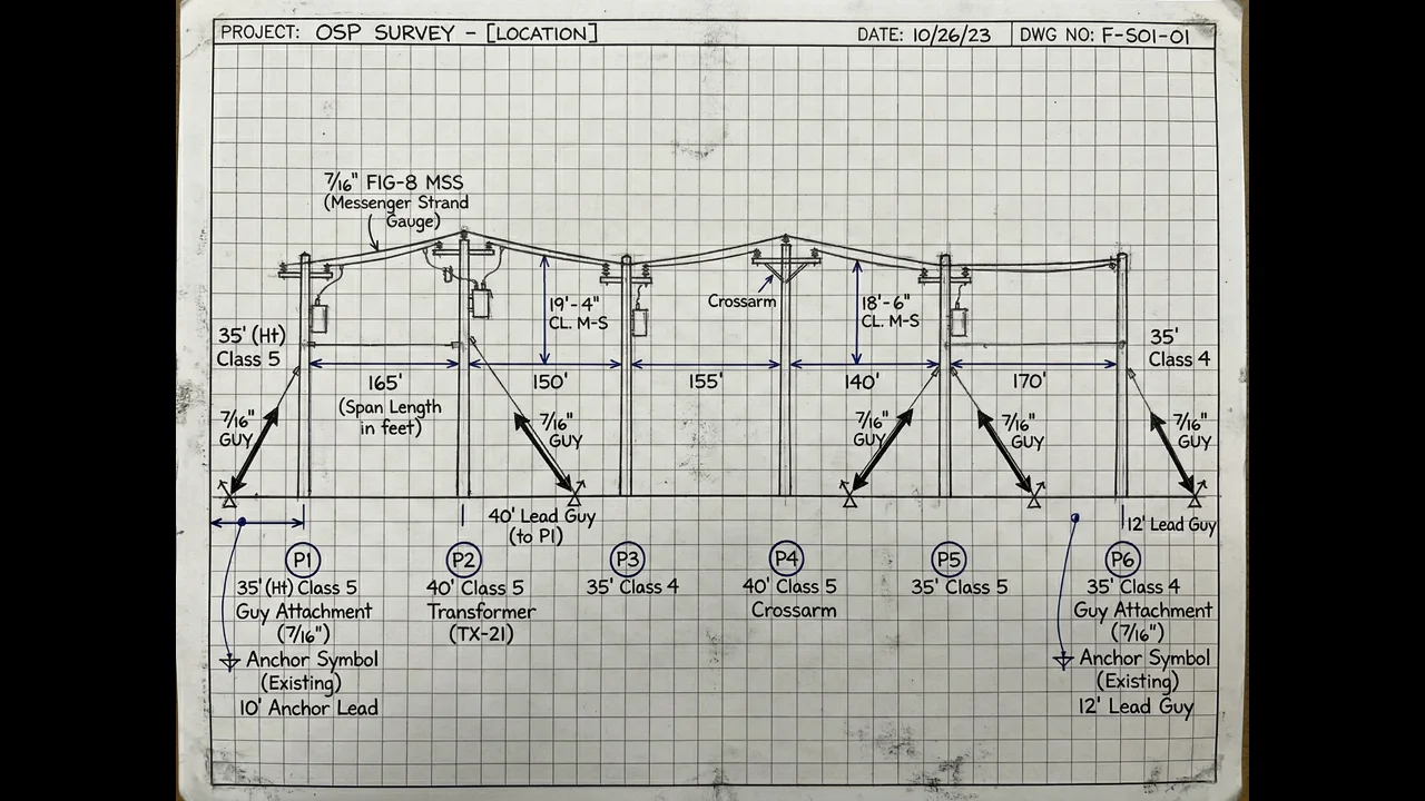
Step 2: Pole-by-Pole Strand Mapping Data Collection
At each pole, a disciplined two-person crew follows a sequence. One person operates the rangefinder and calls measurements; the other enters data and takes photos. You can do it with one person, but the pace drops significantly and errors increase — particularly on complex poles with many attachments.
Pole identification and structural data
First: confirm the pole ID. If the utility company's GIS data has the pole tagged with an ID number, locate that number on the NESC plate or stencil and confirm it matches. If it doesn't match — or if there's no plate — document that discrepancy. It's more common than you'd think, especially on older plant where poles have been replaced without ID updates in the utility's records.
Then: document the pole class and species from the NESC plate if visible. If not visible, make a ground-level assessment based on visible circumference and condition. Document the pole height estimation and any visible structural deficiencies — splits, decay at the ground line, rot holes, woodpecker damage, previous repair banding. Take photos of anything abnormal. On a project in central Mississippi, we found an entire mile of distribution line where a third of the poles had significant ground-line rot that had never been flagged in the utility's inspection records. That discovery changed the make-ready engineering approach for the entire segment.
Attachment inventory
Work from the top of the pole downward. Document every attachment: who owns it, what it is, and its measured height at the pole face. The ownership attribution is where crews frequently get sloppy — particularly on poles with both electric distribution attachments and telecom attachments from multiple carriers. "Unknown telecom" is not an acceptable attribution. You need to identify the attachment to the extent possible from ground level, which typically means identifying the cable sheath markings, the strand stamp markings, and any equipment labels on associated hardware.
Attachment heights are measured from grade — ground level at the base of the pole — using the laser rangefinder. Take measurements from a consistent distance from the pole; most clinometer-based measurement methods require you to be a specific distance away to use the built-in angle calculation. Document the measurement method used, because the downstream engineering team needs to know whether heights are rangefinder-measured or estimated.
Span data
For each span leaving the pole, document: direction to next pole, estimated span length, cable type and count if identifiable, strand condition (acceptable sag, excessive sag, apparent tension problems), and any clearance conflicts with other cables, trees, structures, or traffic lanes. Mid-span sag measurements are taken at accessible points using the fiberglass rod or clinometer method; for most spans, a ground-level observation and photo with a clearance notation is the practical output.
Conflicts and anomalies get flagged immediately. A span that appears to have less than the required NESC clearance to a communication cable below it is a potential violation that needs to be documented and escalated — not noted and forgotten. These are exactly the conditions that ground-level engineering reviews miss and that field survey data accuracy problems create downstream.
Step 3: What Gets Documented at Problem Poles
Not all poles are equal, and the ones that require extra documentation time are worth it. Problem poles tend to cluster around a few scenarios.
Overloaded poles. A pole that already has three or four telecom attachments plus electric distribution, plus a transformer, plus a riser conduit running up one side — that's a pole that needs a full condition assessment, precise height measurements for every attachment, and a note recommending pole loading analysis before any new attachment is added. Don't shortcut the data collection on these because the crew is tired and it's 4 PM. These are the poles that fail make-ready applications and generate the most expensive design revisions.
Multi-pole assemblies. H-frames, double-dead-end structures, guyed corners — these require documentation of every component, including anchor locations, guy wire attachments, and any equipment mounted on secondary poles. The guy anchor location and depth estimate matter for underground route planning; a bore path that intersects an anchor rod is a construction problem that's entirely avoidable with good field data.
Poles with elevation or terrain complications. A pole at the bottom of a ravine has a very different clearance situation than the GIS coordinates suggest. A pole on a hillside where one span is going downhill has a different sag calculation than a level span. These conditions need to be captured in field notes — not just in photos that nobody looks at during office-based engineering.
Step 4: End-of-Day QC and Data Submission
Data collected during the day should be reviewed and submitted at the end of each field day — not held for a weekly batch upload. Daily submission enables the GIS and engineering team in the office to flag data quality issues while the crew is still in the area and can return to specific poles to collect missing information.
The end-of-day QC is the crew lead's responsibility. Review every record from the day: are all required photos present? Are attachment heights populated for every identified attachment? Are span destinations confirmed? Any poles marked as "inaccessible" or "needs revisit" documented with a specific reason?
The office-based QC team should be running automated validation rules against incoming data — field missing, attachment height out of expected range, photo count below minimum — and flagging exceptions for crew review within 24 hours. This QC cycle is what keeps a strand mapping project on schedule. Discovering a systematic data collection error after 400 poles have been surveyed is far more costly than catching it after 40.
Productivity rates to plan for: On a well-organized project in accessible terrain with experienced crew, 35–55 poles per two-person crew per day is a realistic target. Complex urban distribution with many attachments and difficult access will run 18–28 poles/day. Rural branch lines with simple pole configurations and long drive times between poles run 40–60 poles/day. If someone is quoting you 80+ poles/day on complex plant, the data quality is going to reflect that pace.
Step 5: How Aerial Plant Strand Map Data Feeds Into Fiber Engineering
The strand map dataset is not a final product on its own — it's the input for multiple downstream engineering workflows, and understanding those workflows helps field crews understand what data actually matters.
Pole loading analysis. The structural engineer doing the loading calculation in O-Calc Pro or SPIDA Calc needs: pole class, pole height, attachment heights for every existing attachment with owner identification, span lengths and directions, existing cable sizes and weights where determinable. Missing or estimated data in these fields produces loading calculations with wider uncertainty ranges, which typically results in conservative (more expensive) make-ready recommendations or rejected applications that need supplemental field data.
Fiber route design. The OSP design team uses span lengths, pole locations, and attachment heights to plan the fiber cable route — determining splice point locations, cable count requirements, NAP placement, and make-ready complexity per span. Incorrect span lengths produce incorrect cable count estimates. A span that's documented as 200 feet but is actually 247 feet changes the material takeoff for the entire segment. Those kinds of errors, aggregated across hundreds of spans, produce construction cost overruns that are genuinely hard to explain to a client.
Make-ready engineering. The make-ready scope — which attachments need to move, which poles need replacement, which transfer work is required before fiber can be attached — is derived entirely from the field data. This is where the attachment height accuracy matters most. Our field survey services are specifically designed to produce make-ready-grade data, not just a general inventory.
Permit applications. Railroad crossing permit packages, highway ROW applications, municipal access permits — many of these require specific field data about existing attachments on poles within the project limits. A strand map that was collected to make-ready engineering standards typically satisfies permitting data requirements without additional field work.
Common Strand Mapping Mistakes That Compromise the Aerial Plant Survey
We audit a lot of strand map datasets that were collected by other teams — either as part of a project takeover or as a QC review before engineering begins. The same errors show up consistently.
Estimated attachment heights presented as measured. This one is pervasive. A crew that gets behind schedule starts estimating heights instead of measuring them, but enters the data in the "measured" field rather than flagging it as estimated. The downstream engineering team has no way to know — they trust the data until the pole loading calculation produces a result that doesn't make sense. Then someone has to go back to the field.
Missing spans. A pole at a T-intersection has three span directions. A crew that's moving quickly might document two and miss the third because the route continuation is obvious in the field but the documentation is incomplete. Missing spans are usually caught in QC, but not always, and a fiber route design that's missing a span records a shorter route than actually exists.
Ownership attribution as "unknown" for everything. We understand that strand identification from the ground isn't always possible. But "unknown" should be the exception, documented with a reason — "no markings visible, attachment at 24.3 ft, apparent 6-fiber coaxial with CATV strand" — not a default for any attachment that requires more than 30 seconds to identify.
Solid strand mapping is the foundation of solid fiber design. The pole loading analysis depends on it, the route design depends on it, and ultimately so does the construction cost model. If you have an aerial plant assessment coming up and want a team that's done this at scale across 22 states, our team at Draftech field survey services is worth a conversation. Reach out to us at info@draftech.com — we can talk through scope, methodology, and what the data output looks like before anything is contracted.