Every time I get asked "what does OSP fielding cost per mile?" I give the same answer: it depends. That's not a dodge — it's the honest truth — but I know it's not helpful if you're trying to budget a project. So let me break down what actually moves the number, give you some real ranges, and help you figure out why two quotes for the "same" job can differ by 3x.
Short version: a basic aerial route walk in flat terrain might cost $350–$600 per mile. Full photogrammetric data collection for a make-ready-ready package in mountainous western terrain can run $1,400–$1,800 per mile. Both are fiber field surveys. The difference is scope, terrain, and what data you walk away with.
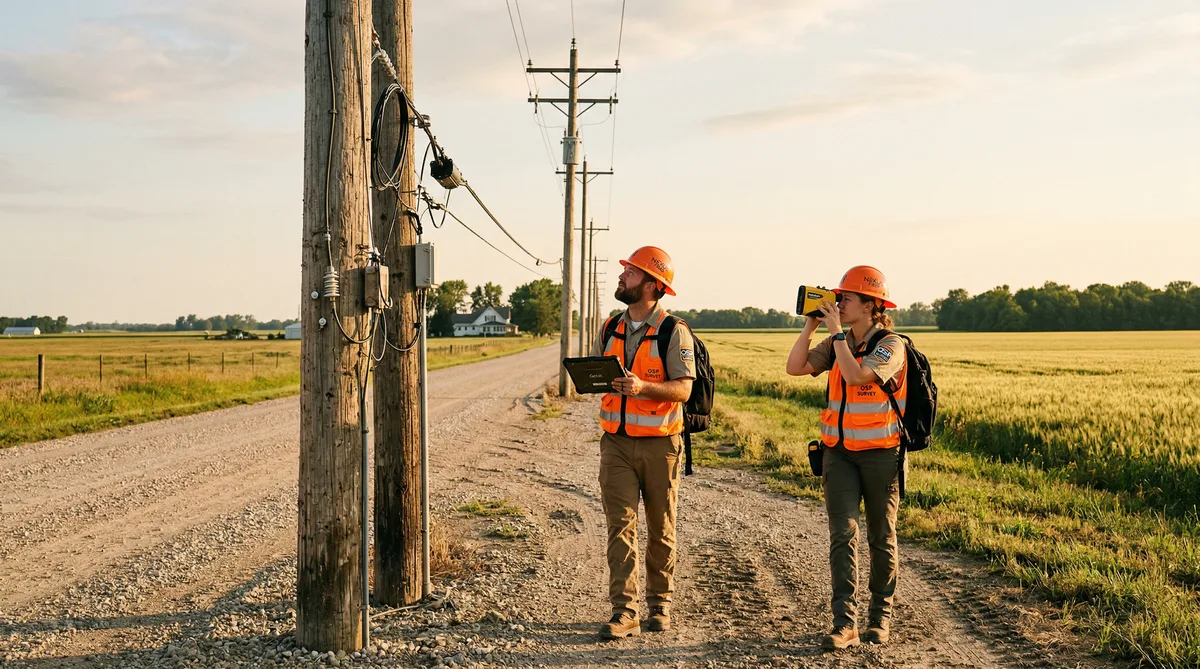
The Main Variables That Drive OSP Fielding Cost Per Mile
Aerial vs. underground is the first split. Aerial OSP fielding is priced per mile because the crew is walking or driving a route, counting poles, verifying strand, and collecting attachment data. Underground is priced differently — usually per structure (handhole, manhole, pedestal) — because there's no reliable correlation between route distance and structure density. A downtown urban route might have 14 structures per 1,000 feet. A suburban feeder route might have 4. Mixing those into a single per-mile rate is how estimates go wrong.
For aerial work, pole count per mile matters more than the miles themselves. Dense residential neighborhoods often run 18–22 poles per mile. Rural routes might drop to 12–15. The difference sounds small, but when you're doing full data collection — photos, GPS, height measurements, attachment inventory — every pole takes 8–15 minutes. That math adds up fast. A crew covering 16 poles per mile at 10 minutes per pole spends roughly 160 minutes just on pole data, before you account for travel between poles, Fulcrum entry, and any problem poles that need a second look.
Terrain and Access
This is the biggest single variable, and it's the one most ISPs underestimate when they build budgets. Flat suburban routes with paved road access? A two-person crew can cover 4–6 miles per day doing mid-tier data collection. Rocky Appalachian terrain, thick Georgia pine forest, or Pacific Northwest hillside routes? That same crew might cover 1.5–2 miles on a good day.
We ran a project in central West Virginia a few years back — about 47 route miles that looked perfectly manageable on a map. The field reality was something else. Half the poles were 50–100 feet off the road, accessible only by foot through steep grade changes. Took us 31 field days with a two-person crew to complete what we'd estimated for 18 days. Terrain is not an abstraction. It's labor hours, and labor hours are money.
Wetlands add another layer of cost. Many rural routes in the Southeast and upper Midwest cross wetland buffers where field crews need to be careful about access timing, documentation, and sometimes permitting just to do survey work. That's before construction ever starts.
Urban vs. Rural Cost Dynamics
Here's a counterintuitive one: urban fielding often costs more per pole than rural, even though the poles are easier to reach. Traffic. A crew working in a dense urban corridor — think inner-ring suburbs of Atlanta or Baltimore — spends a significant portion of their day managing traffic, parking, and access. They may need a two-person team specifically because one person has to manage vehicle and road safety while the other works the pole. In some jurisdictions, urban pole work near major roads requires formal MOT setup, which is a whole separate cost line.
Rural routes have different problems. Mobilization. A project 3 hours outside of Albuquerque means either your crew is driving 6 hours round-trip every day (which you're paying for) or you're paying for per diem, lodging, and meals. That per diem cost gets spread across the miles fielded, and on short rural deployments, it can easily add $200–$400 per mile to the effective cost.
Scope Tiers: What You're Actually Buying
Most ISPs and contractors don't realize that "field survey" describes three very different scopes. The price difference between them is enormous, and picking the wrong tier will cost you far more in redesigns than you saved on the survey.
Tier 1 — Basic Route Walk
Route verification, aerial strand confirmation, rough pole count, and basic condition notes. No GPS coordinates, no per-pole photos, no attachment height data. This might run $250–$450 per mile and is appropriate for very early-stage feasibility or route screening — the "does this route even make sense?" question before you commit to detailed engineering. Don't use this for anything that feeds into design directly.
Tier 2 — Standard Pole Data Collection
GPS coordinates per pole, pole owner, pole class and height estimate, existing attachment inventory with heights, existing strand identification, and ground-to-sky photos. This is what most make-ready engineering firms need as an input for O-Calc or SPIDA Calc loading analysis. Depending on terrain and region, this runs $550–$950 per mile for typical suburban aerial routes.
Good execution at this tier — meaning solid field survey data accuracy — is what separates a clean make-ready package from one that generates 40 field verification RFIs during construction. The downstream cost of fixing bad Tier 2 data is almost always higher than the cost of doing Tier 2 properly.
Tier 3 — Photogrammetric / Katapult-Level Collection
This is the full package. Every pole gets photographed from multiple angles, the images are uploaded to Katapult (or equivalent), and the platform processes attachment heights, span lengths, and mid-span clearances from the photos. The output feeds directly into loading analysis without a separate measurer visit.
Cost runs $900–$1,600 per mile depending on pole density and terrain. The premium over Tier 2 is real, but so is the value: you're essentially buying your make-ready field visit in advance and rolling it into the fielding cost. On large projects — say, 200+ miles of aerial route — the savings on avoided make-ready remeasures can more than pay for the Tier 3 premium. We've done the math on this across multiple BEAD-scale projects, and the crossover point is usually around 80–100 miles of aerial route.
The strand mapping process is often bundled into Tier 2 or Tier 3 collection — just make sure your SOW explicitly defines what strand data is being captured, because "strand mapping" means different things to different firms.
How Bad Survey Data Costs You More Downstream
This deserves its own section because it's where I've seen the most money wasted — not by paying too much for fielding, but by paying too little for bad data and then paying twice.
The pattern usually looks like this: an ISP gets competing quotes for fielding, picks the lowest one, and the crew delivers GPS coordinates that are off by 20–40 feet, attachment heights that are estimated (not measured), and photos that are too dark or angled to be useful. The design team builds HLD and LLD off that data. Make-ready engineering catches the discrepancies in the field. Construction hits poles that weren't in the survey. The project manager issues redesign orders. Each one costs engineering time, and each one delays the project.
On a 90-mile aerial project we took over from another firm in Mississippi, we found that roughly 23% of the poles in the original survey had at least one data error significant enough to affect the make-ready calculation. That's not an outlier — it's what happens when fielding crews are under pressure to cover miles rather than collect accurate data.
Rule of thumb: Every dollar saved on low-quality fielding tends to generate $3–$7 in downstream redesign, remeasure, and construction problem costs. The math almost never works in favor of the cheapest survey quote.
Hidden Costs in OSP Field Survey Pricing
The line items that appear in quotes vary a lot between firms. Make sure you understand what's included — and what isn't — before comparing numbers.
Mobilization. Some contractors include travel within a radius, others bill it separately. On remote rural projects, mobilization can represent 10–20% of total cost. Ask specifically: is per diem, lodging, and mileage included in the per-mile rate?
Data QC and processing. Collecting data in the field is one step. Getting that data into a usable format — cleaned, QC'd, and structured — is another. Some fielding contractors hand over raw Fulcrum exports and consider the job done. Others include a QC pass and deliver formatted shapefiles, spreadsheets, or Katapult exports. The QC step is not glamorous, but it's where errors get caught before they cascade downstream.
GIS deliverable formatting. If your design team works in ArcGIS and your fielding contractor delivers data in a format that requires conversion, someone pays for that conversion. A clean geodatabase schema agreed on upfront saves hours of back-and-forth. We've delivered ArcGIS feature classes, AutoCAD overlays, KML files, and custom Katapult exports depending on what downstream workflows require — but that scope needs to be defined before the crew goes out, not after.
Permit fees for survey access. Certain jurisdictions, rail corridors, and state DOT routes require permits just to access the right-of-way for survey purposes. These fees are often pass-through costs, but if they're not explicitly mentioned in the quote, they can show up as change orders.
BEAD Projects and Why Fielding Scope — and Cost — Increases
If you're fielding for a BEAD-funded deployment, the scope requirements are meaningfully different from a standard commercial build, and your fielding costs should reflect that. Understanding BEAD engineering requirements before you finalize your survey SOW will save significant headaches later.
NTIA expects documentation at the BSL (Broadband Serviceable Location) level. That means your field survey needs to confirm physical passability of routes that serve specific addresses — not just confirm that a route is generally buildable. Crews may need to document that specific BSL locations are within serving range of the proposed network architecture. That's a different task than a standard route walk, and it takes more time per mile.
Environmental and historic preservation documentation requirements under NEPA and Section 106 also affect fielding scope on federally funded projects. In some states, field crews need to document vegetation, water crossings, and adjacent structures in ways that support the environmental review. That adds data collection time — and the documentation deliverables add QC and formatting time on the back end.
On BEAD projects we've fielded in recent cycles, the total effective cost per mile runs roughly 20–35% higher than comparable non-BEAD aerial fielding due to increased documentation scope. Budget for that upfront. It's much harder to recover from a low-ball fielding budget mid-project when state program administrators are waiting on deliverables.
Outsourcing vs. In-House: When Each Makes Sense
For small ISPs — under 500 route miles of planned buildout — in-house fielding almost never pencils out when you run the true loaded cost. You need vehicles equipped for field work, GPS-capable tablets or handhelds loaded with Fulcrum or a similar platform, training for data collection standards, and a QC process. The fully loaded annual cost for a two-person in-house fielding team — salary, benefits, equipment, vehicle, training — typically runs $180,000–$240,000 per year. That's real money to carry if the crew isn't busy 11 months of the year.
For larger ISPs and carriers running continuous builds across multiple states, in-house fielding makes more sense — but only with disciplined resource management. The crews need to stay productive year-round, which means coordinating fielding, make-ready remeasures, and construction verification all under one team umbrella. That's a management capability, not just a staffing one.
Outsourcing to a firm that has established crews, equipment, and QA processes lets you scale up and down with project volume. The per-mile rate looks higher than in-house on paper, but when you account for idle time, overhead, and the QA that a good contractor includes, the math usually favors outsourcing up to a fairly large volume. Our field survey services are structured specifically for ISPs who want accurate data without carrying the overhead of a standing field team.
One thing I've seen hurt ISPs: they hire in-house for fielding, the field build slows down, the crew idles for three months, and then the ISP is tempted to redeploy the crew on tasks they weren't trained for. That almost never ends well. If you're going in-house, commit to keeping the crew productive — or plan for the outsource cycle during slow periods.
Getting a Useful Quote: What to Define Upfront
If you want quotes that are actually comparable, define these things before you go out for bids:
- Route miles (aerial vs. underground split)
- Estimated pole count (even a rough number helps)
- Terrain description — flat suburban, hilly, wooded, rural with limited access
- Data deliverable format — Katapult, ArcGIS shapefile, Fulcrum export, spreadsheet
- Photo requirements — quantity per pole, resolution, direction
- QC process — who does it, what's the rejection standard
- Whether mobilization and per diem are included or separate
- BEAD documentation requirements, if applicable
A SOW that defines all of these will generate quotes you can actually compare. Without it, you're comparing apples to unspecified citrus.
There's also value in asking prospective fielding contractors how they handle discrepancies — what happens when a pole doesn't match the GIS data, or when access is blocked. The answer tells you a lot about how the crew will behave in the field without supervision.
Frequently Asked Questions
How much does OSP fielding cost per mile?
OSP fielding cost per mile typically ranges from $350 to $1,800+ per mile depending on scope, terrain, and required deliverables. A basic aerial route walk in flat suburban terrain might run $350–$600 per mile. Full pole data collection with photos, GPS, and Katapult-level photogrammetry in mountainous or densely wooded areas can exceed $1,500 per mile. Urban underground work is priced differently — often per structure rather than per mile.
What is included in a fiber field survey scope?
At minimum, a fiber field survey scope covers route verification, aerial strand identification, and basic pole count. Mid-tier scopes add pole GPS coordinates, existing attachment heights, pole class/species, and ground-to-sky photos. Full-scope Katapult-level collection includes photogrammetric data for every pole, which can feed directly into make-ready engineering without a separate field visit. What's included — and what's not — matters enormously when comparing quotes.
Is it cheaper to outsource OSP fielding or do it in-house?
For small ISPs without a standing field crew, outsourcing is almost always cheaper when you factor in the fully loaded cost of in-house staff: salary, benefits, vehicle, equipment, training, and QA overhead. For ISPs running continuous large-scale builds, an in-house crew can be cost-effective — but only if they're kept busy year-round. The hidden cost of in-house fielding is idle time between projects.
How does terrain affect OSP fielding cost?
Terrain is one of the biggest cost drivers in OSP fielding. Flat suburban routes with paved road access might allow a crew to cover 4–6 miles per day. Rocky, wooded, or mountainous terrain can cut that to 1–2 miles per day, which multiplies your labor cost by 2–3x. Wetlands, river crossings, and steep hillsides also add safety and access costs. Travel mobilization to remote rural areas adds a fixed cost regardless of route length.
What data should a fiber field survey collect?
At a minimum: pole ID or NESC tag, GPS coordinates, pole owner, existing attachments with heights, estimated pole class and height, and existing strand/fiber presence. For make-ready-ready surveys: add ground line measurements, highest attachment height, mid-span clearance estimates, pole condition notes, and ground-to-sky photos. For BEAD or grant-funded projects: add BSL address proximity, route photos for environmental documentation, and GIS-ready shapefiles or Katapult exports.
If you're pricing a fielding scope and want a second opinion on what tier makes sense for your project, or if you're trying to figure out why two quotes look so different, we're happy to talk it through. Our team has fielded routes in all kinds of terrain across 22 states — we've seen most of the ways this can go sideways, and we can help you structure a scope that doesn't blow up downstream. Reach out at info@draftech.com or take a look at our fielding services to understand how we approach it.