Garbage in, garbage out. It's an axiom old enough to be cliché, but in OSP engineering it describes the mechanism behind the majority of construction change orders more precisely than any other phrase. When a field survey crew records the wrong strand height, misses an existing attachment, or doesn't document the pedestal location on the adjacent property, those errors propagate forward. The design engineer uses the wrong data. The construction drawings reflect that wrong data. And the field crew — six months later, when construction begins — is the first person to discover the problem. At construction rates.
We track change orders carefully across our projects. The 90% figure in the title isn't rhetorical. Over a multi-year sample of fiber deployment projects where we managed both the survey and the engineering, we traced the root cause of construction change orders back to their origin point. Roughly 88–92% of those change orders originated with a field survey error or omission that wasn't caught during design QA. The remainder were genuine site conditions that no survey methodology could have predicted — a buried structure that predated all records, a subsurface obstruction in a location with no utility markings. Those are genuinely unforeseeable. Everything else was preventable.
The Fiber Field Survey Data Points That Field Crews Miss Most Often
Fiber field survey data accuracy problems cluster around five consistently missed data types: mid-span clearance measurements, precise attachment heights at non-standard poles, underground utility conflict documentation, GPS coordinate precision below required tolerance, and pole condition flags at borderline structures. These are not random omissions — they're systematically undervalued in survey scope agreements, which is why they drive the majority of construction change orders.
Survey errors aren't random. They cluster around specific data types that are consistently undervalued in field survey scope agreements — the items that are slightly harder to measure, slightly less obvious to a non-engineer crew, or that don't become important until a specific design decision is made weeks later. Understanding which data points are systematically missed is the starting point for a survey quality program that actually works.
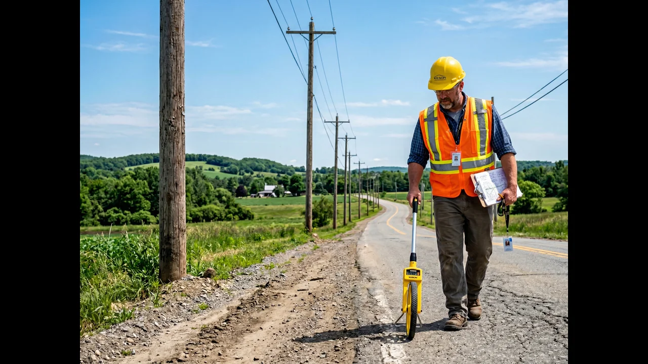
Strand and Attachment Heights: The Clearance Problem
NESC Table 232 specifies minimum vertical clearances for communication cables over roadways (18.5 feet over high-traffic roads), over driveways (16 feet), and in various other configurations. These clearances drive attachment height requirements — specifically, whether a new fiber lashing on an existing strand meets clearance at the lowest point in the span, accounting for sag under NESC loading conditions.
A field crew recording attachment heights with a measuring wheel and a tape — or estimating heights visually — will often produce numbers accurate to ±1.5 to 2.0 feet. That margin sounds tolerable. It isn't. On a span where the existing strand is recorded at 23 feet and the actual height is 21 feet, the new fiber attachment designed for that 23-foot height may fail clearance by 18 inches once the sag from the cable weight is applied. The construction crew discovers this when they're already on the pole, which means a field engineer visit, a design revision, and a change order — for a data point that should have been measured with a laser at 6 inches of precision during the survey.
Optical height measurement tools — the Laser Technology TruPulse, the Leica DISTO — can measure attachment heights from the ground to 6-inch precision in seconds. There's no reason not to use them. Survey scopes that allow or budget for visual height estimation are creating change orders.
Existing Attachment Inventory: What's Actually on That Pole
Make-ready engineering for a pole loading analysis is only as good as the existing attachment inventory. Missing an attachment from the survey data means it doesn't go into the O-Calc Pro model, which means the analysis result is wrong, which means the permit package is potentially approving an attachment on a pole that's already overloaded.
The specific attachments that get missed most often: risers (the vertical conduit runs that carry cable from the aerial strand down to an underground segment or a pedestal), cable television lashing that's been buried by foliage and isn't obvious from street level, illegally attached wireless equipment that doesn't appear in any utility record, and guy wires that don't originate from the pole being surveyed but do affect the lateral forces on it. A good survey crew inventories everything from the ground anchor to the top of the pole, photographs every attachment, and records it with its height and directional bearing.
Pole Condition and Class: The Foundation of Loading Analysis
An O-Calc Pro model requires the pole's class and species. Those come from the stamp on the pole. They also require the pole's effective strength — its rated moment capacity at ground line — which for an in-service wood pole is affected by decay, checking, and the setting depth. A Class 3 Douglas Fir pole that was new in 1992 does not have the same structural capacity as a new Class 3 Douglas Fir pole. Decay at the ground line — which affects virtually all wood poles after 30+ years — can reduce effective capacity by 30–50%.
Survey crews who record pole class from the stamp and nothing else are providing incomplete data. A basic visual condition assessment — presence of significant checking, visible decay indicators, lean angle, evidence of insect damage at the butt — is a standard part of a complete pole survey. On poles that appear significantly degraded, our survey protocols flag them for OTMR (One-Touch Make-Ready) evaluation or for pole replacement recommendation before the engineering analysis even begins. Catching a pole that needs replacement in the survey phase is a design revision. Catching it in the make-ready analysis phase is a permit revision. Catching it during construction is a change order.
Underground Conflicts: The Most Expensive Survey Miss
Underground utility conflicts are the single most costly survey error category on direct-buried or bored fiber deployments. A bore path conflict with an unmarked gas main isn't a change order. It's a potential safety emergency, a construction shutdown, and a regulatory event in addition to the project cost impact.
811 markings are necessary but not sufficient. Private utilities — pipelines on private property, irrigation systems, building services — often aren't in 811 databases. Municipal utilities in some jurisdictions have records that are 20+ years out of date. Fiber that was bored five years ago by a previous provider may not be in any record system at all.
Thorough underground survey for a fiber route includes 811 calls followed by vacuum excavation test holes at conflict points — particularly at road crossings, at building service entrance locations, and anywhere the GIS utility records show a density of underground infrastructure. The cost of a vacuum excavation test hole is $300–$500. The cost of hitting an unmarked gas main is measured in hundreds of thousands of dollars and doesn't include the intangibles of a serious safety incident.
| Conflict Type | Detection Cost (Survey) | Discovery Cost (Construction) | Multiplier |
|---|---|---|---|
| Buried utility conflict | $400 vacuum ex. test hole | $8,000–$25,000 reroute + delay | 20–60× |
| Wrong strand height | $50 laser measurement | $2,500–$6,000 field revision | 50–120× |
| Missing attachment | $25 photo + inventory | $3,500–$12,000 permit re-analysis | 140–480× |
| Wrong pole class | $40 stamp + condition check | $2,000–$5,000 pole replacement | 50–125× |
GPS Integration and Geolocation Standards for Fiber Field Survey Data
GPS integration in fiber field survey means every pole record carries a coordinate accurate to within 1–3 meters, captured automatically by the collection device — not estimated from a street address. Survey data without georeferencing is directional at best and introduces manual entry errors when converted to GIS. BEAD programs and most engineering workflows require GPS-verified coordinates for all structures and cable route centerlines.
Field survey data that isn't georeferenced is directional at best. A crew recording pole locations in a field notebook — "Pole 14, northwest corner of Oak and Main, approximately 30 feet from corner" — is producing data that requires interpretation and manual entry to be useful to an engineer. That interpretation and entry process introduces errors and takes time.
Every data point in a modern OSP field survey should be collected with GPS coordinates at sub-meter accuracy, tied to the WGS84 datum, and recorded in a format that flows directly into GIS. Sub-meter accuracy isn't exotic — it's available with a GNSS-enabled collector like a Trimble R1, a Juniper Systems Geode, or a Leica Zeno, all of which integrate with mobile GIS platforms and can be used by a field technician without advanced surveying training.
The GPS data doesn't just help the engineer — it enables the automated QA checks that catch gross errors before they enter the design process. A pole location that's 800 feet from the nearest road is probably a GPS dropout, not a real pole location. An attachment height of 4 feet is probably a data entry error, not a real measurement. These checks catch the obvious errors automatically. The subtle errors — a height that's 2 feet wrong, a pole that's 15 feet from its recorded location — require the photo documentation and manual QA review discussed below.
Fulcrum and Mobile GIS Workflows: What Good Data Collection Looks Like
The field data collection workflow that produces consistently reliable OSP survey data in 2026 looks like this: survey technicians equipped with calibrated GPS units and mobile devices running a structured data collection app — Fulcrum, Survey123, or a custom mobile GIS app built on ArcGIS Field Maps — that enforces field completeness through required fields and validation rules.
Fulcrum is particularly well-suited to OSP surveys because it allows custom form design that mirrors your survey data schema exactly. A pole survey form in Fulcrum requires: GPS-captured coordinates, pole number from the stamp, pole class and species, a height measurement from the laser, the required photo set (four cardinal views plus close-up of stamp and all attachments), a condition assessment with dropdown selections that force a deliberate evaluation, and a field for each attachment type with its height and bearing. Every field is required. The form won't submit without complete data. That requirement-at-source is worth more than any after-the-fact QA check.
Data submitted through Fulcrum flows directly into a cloud GIS database in near real-time, where QA engineers can review it the same day it was collected — not weeks later when the crew is long gone and any discrepancy requires a return trip. That QA-during-survey workflow is how you catch the data quality problems before they become engineering problems.
The QA/QC Checkpoint Missing from Most Fiber Field Survey Contracts
Most survey scope agreements define deliverables — a survey dataset in a specified format, delivered by a specified date — without defining the quality standard that dataset must meet before it's accepted for engineering use. That gap is where bad data slips through.
Our survey QA protocol includes a formal data acceptance review that happens before the survey dataset is handed to the engineering team. Every pole is checked against a QA checklist: GPS coordinates plotted in GIS and reviewed against aerial imagery for plausibility, attachment heights cross-checked against the photo documentation, condition assessments verified against the photo set, span measurements validated against the pole location data. Any pole that fails a QA check goes back to the field for a revisit — before engineering begins, not after.
This adds 5–8% to the survey cost. It consistently reduces construction change orders by 35–50% compared to projects where survey data is accepted without formal QA. Every client who has seen both the change order log from a project without survey QA and the one from a project with it has paid for the survey QA on every subsequent project.
At Draftech, our field survey teams cover 22 states with the GPS equipment, mobile GIS workflows, and QA protocols described here. If you're planning a fiber deployment and want a survey partner whose data quality translates directly into lower construction cost, contact us at info@draftech.com.